Western US Radiation Map - Full U.S. Map

 |
|
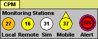
How the Map Works: A growing number of Radiation Monitoring Stations across the country (and world), using various models of Geiger Counters, upload their Radiation Count data in real time to their computer using a Data Cable, and then over the Internet to this web site, all of this accomplished through GeigerGraph for Networks software. This system is completely automated - there is no manual posting of data required. How to Read the Map: Referring to the Map Legend at the bottom left corner of the map, locate Monitoring Stations around the country that are contributing radiation data to this map as you read this, and watch the numbers on those monitoring stations update as frequently as every minute (your browser will automatically refresh). The numbers represent radiation Counts per Minute, abbreviated CPM, and under normal conditions, quantify the level of background radiation, i.e. environmental radiation from outer space as well as from the earth's crust and air. Depending on your location, your elevation or altitude, and your model of Geiger counter, this background radiation level might average anywhere from 5 to 60 CPM, and while background radiation levels are random, it would be unusual for those levels to exceed 100 CPM. Thus, the "Alert Level" for the National Radiation Map is 100 CPM, so if you see any Monitoring Stations with CPM value above 100, further indicated by an Alert symbol over those stations, it probably means that some radioactive source above and beyond background radiation is responsible. Notice the Time and Date Stamp at the bottom center of the Map. That is Arizona Time, from where we service the Network, and your indication of how recently the Radiation Levels have been updated to the Map. |
|